

Grafton, Illinois, September 26 38°58'07"N 90°26'45"W, Elevation 420 feet
Looking across the Mississippi River downstream from the point where the Illinois River enters the larger river, a white cairn rests on the shore in Grafton, Illinois. The water in the foreground is from the Illinois, while the islands in the background are in the Mississippi River.
Two Rivers National Wildlife Refuge, Calhoun Division, Brussels, Illinois, September 26, 2022
38°57'04"N 90°30'51"W, Elevation 430 feet
Two Rivers National Wildlife Refuge was established in 1958 to protect and enhance habitat for migratory birds. Located between the Mississippi River and Illinois River, the refuge encompasses 9,225 acres of riverine and floodplain habitat scattered around the confluence.

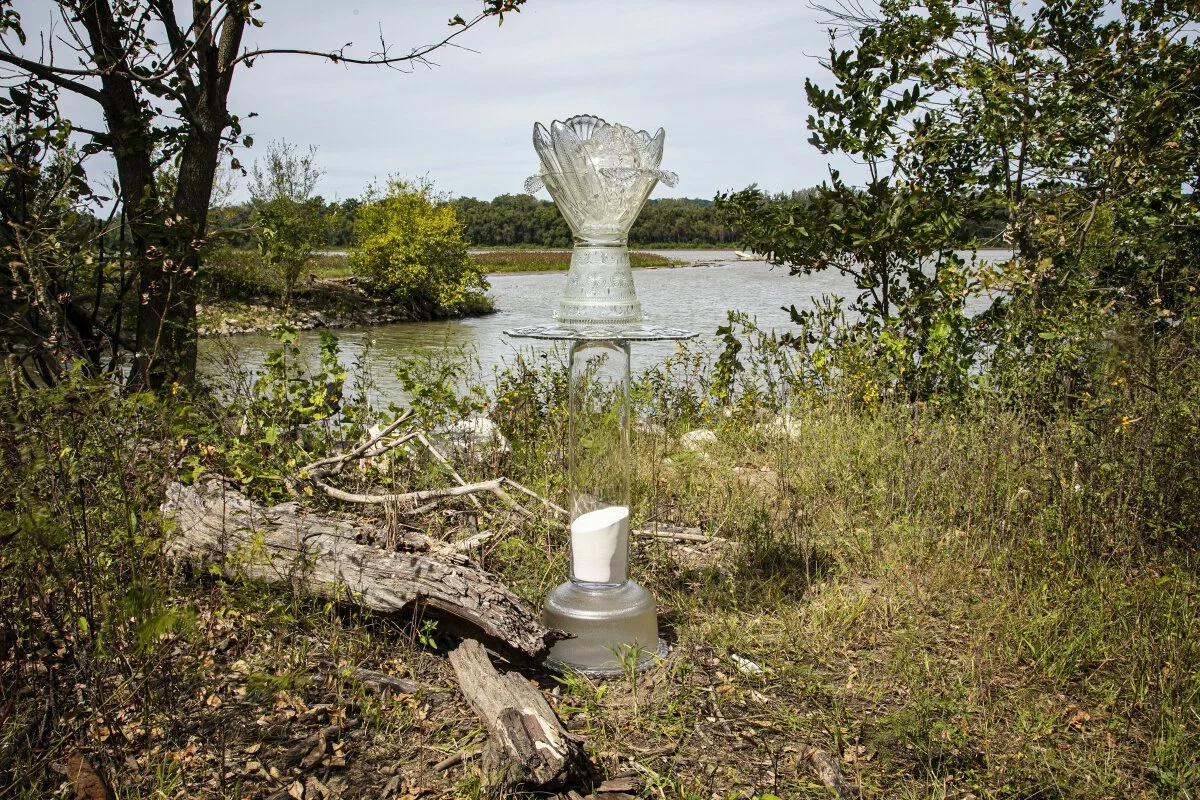
Eagle Roost Overlook, Pere Marquette State Park, Grafton, Illinois, October 19, 2022
38°58'40.5"N 90°32'08"W, Elevation 800 feet
This image features the Abundant Cairn celebrating the 460 plants and 100 amphibian, reptile and mammal species that find their home in the large protected landscape of Pere Marquette State Park.

Hadley Landing Road, Brussels, Illinois, September 26, 2022
39°02'07"N 90°34'43"W, Elevation 430 feet
Located just downstream from the leaf-shaped Twelvemile Island in the Illinois River and the Glades State Fish and Wildlife Management Area, the Fish Cairn reminds us that the historically clear waters of Illinois River supported the river valley’s economy with fish, freshwater mussels, waterfowl, and natural ice before the many levees increased sediment in the water, and the sewage and industrial waste from Chicago brought pollution in the early 1900s.
Stump Lake Road, off Highway 100, near Fieldon, Illinois, May 8, 2018
39°01’10"N 90°33’53" W, Elevation 430 feet
The Milkstone Cairns nestle among the cypress knees in the well-named Stump Lake at the edge of the Illinois River.

Near Orchard and Park Streets, Hardin Illinois, May 5, 2019
39°09'06"N 90°37'05"W, Elevation 440 feet
The 2019 flood covered streets near the Illinois River, flooding homes and garages. Initially, the nearby riverfront restaurant adapted by serving take-out only, until it was surrounded by water and forced to close until the waters subsided and the road was restored.

Off highway 35 east, Hardin, Illinois, September 26, 2022
39°09'13"N 90°36'35"W, Elevation 430 feet
Joe Page (1845–1938) was beloved in Hardin for his generosity to the community and through his work to establish water, electrical, and telephone service to this agricultural area. He was responsible for the creation of this bridge carrying Illinois Route 16 and Illinois Route 100 over the Illinois River. In 1931, Joe Page, editor of the Jersey County Democrat, and John D. McAdams, editor of the Alton Telegraph, established the State Park Committee that was responsible for the creation of Pere Marquette State Park.
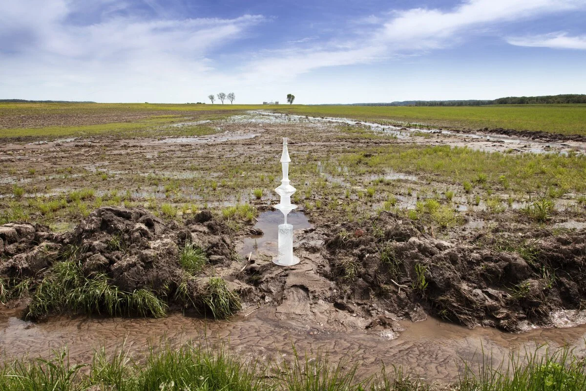
Emerald Valley Farm, White Hall, Illinois, May 5, 2019
39°27'21"N 90°35'47"W
The Rocketship Cairn balances cairn on the muddy edge of a rain-soaked field. Storms can wash essential topsoil, fertilizers, and other agricultural chemicals into ditches that drain into local streams. This is a big financial loss for farmers, pollutes downstream drinking water, contributes to algae growth that chokes rivers, and contributes to the hypoxic or “Dead Zone” in the Gulf of Mexico. Sustainable farming techniques help keep soil and chemicals on the land and out of the water.

McCully Heritage Project, Crawford Creek Road, Kampsville, Illinois, September 26, 2022
39°16'52"N 90°37'22"W, Elevation 440 feet
This wetland, right off the parking area in the 940-acre nonprofit nature park, was relatively dry but a bit spongy, allowing the cairn to rest among the native plants and fallen branches. With miles of well-marked trails to view on foot or horseback there is more to see at the McCully Heritage Project.

Near Frost Airport, Winchester, Illinois, September 27, 2022
39°33'44"N 90°34'15"W, Elevation 420 feet
The relatively straight line of this creek, that flows through an agricultural field then disappears in the culvert under the road under the the cairn suggests it is a drainage ditch rather than a natural streem. But the many native plants growing on either side, the frogs jumping into the water, and the butterflies and herons flying above it, reveal a healthy ecosystem unusual in other drainage ditches.

West Green and Oak Streets, Bluffs, Illinois, September 27, 2022, 39°45'02"N 90°32'13"W, Elevation 480 feet
A blue and clear glass tower-like cairn sits in front of a grain mill and adjacent to the train tracks in downtown Bluffs. The town’s name is puzzling, because its elevation is only 20 feet higher than other locations next to the Illinois River, such as Naples, four miles to the west. Looking at the Google Earth map, it become clear that Illinois Route 100 follows this slight rise that divides the rich agricultural soil in the river’s traditional flood plain from the slightly elevated wooded area.

Island Road near Indian Creek, Beardstown, Illinois,September 27, 2022, 39°55'18"N 90°31'59"W, Elevation 440 feet
South of the La Grange Lock and Dam and downriver from La Grange Island, the clear-and-silver-glass cairn sits at the mouth of Indian creek. The creek originates northeast of Jacksonville, at first meandering through woods and agricultural fields, becoming straighter and hugging the edges of fields as it flows west to meet the Illinois River.

Schmoldt Memorial Park, Marina Levee Road, Beardstown, Illinois, September 27, 2022
40°01'17.7"N 90°25'21"W, Elevation 440 feet
The white-glass cairn rests in front of the round metal cover on one of two concrete water control structures in the levee. This earthen levee separates the agricultural areas north of Beardstown from Meyer Lake, a marshy flood plain of the Illinois River. These structures allow excess water from an unnamed creek and pond to be released into the lake and river.

Highway 100, Sanganois State Fish and Wildlife Area, Browning, Illinois, September 27, 2022
40°08'19"N 90°20'51"W, Elevation 450 feet
Snake Grass, scouring rush, and horsetail are common names for Equisetum hyemale, the segmented evergreen plant that surrounds this white-glass cairn in the woods of the Sanganois State Fish and Wildlife Area. The plant is common in Europe, Canada and the northern parts of the US, and pieces of the woody plant have been found between the teeth of herbivorous dinosaur skeletons.

Highway 9, Emiquon National Wildlife Refuge, Lewistown, Illinois, September 27, 2022
40°20'30"N 90°05'35"W, Elevation 440 feet
The observation station to the right of the clear-and-patterned-glass cairn looks out on Emiquon National Wildlife Refuge near Havana, Illinois. While there is only a picturesque stream in this autumn image, in the spring, this land floods and fills with birds and aquatic life. The bed of two shallow lakes that were drained in the 1960s was returned to its former state by The Nature Conservancy, a nonprofit, and the US Fish and Wildlife Service. They cooperate to manage this 11,122 acre reserve, a designated Ramsar Wetland of International Importance site.

Rice Lake State Fish and Wildlife Area, Highway 24, Banner, Illinois, September 27, 2022
40°28'36"N 89°56'50"W, Elevation 450 feet
The clear-and-silvered-glass cairn reflects the colors of the evening sky and water at this boat landing by a sign proclaiming it to be “Miserable Lake.” It is separated from the main channel of the Illinois river to the east by a larger body of water labeled Rice Lake, Goose Lake, and Big Lake. To the west is the Duck Creek Cooling Pond of a natural-gas-fired electricity generating facility.

Illinois State Fish and Wildlife Area, Powerton Lake, Highway 16/County Road 1500N, Pekin, IllinoisSeptember 28, 2022
40°32'19"N 89°42'03"W, Elevation 450 feet
The H2O cairn, created from a fish bowl and other glass containers, sits on the boat dock on the cooling lake for the Powerton coal-fired electric power generating facility. Powerton is one of the ten (there are thirteen) Illinois coal-fired plants slated to be closed by 2030 as a result of Illinois state laws designed to improve air quality and to decrease carbon emissions.

Henry Harbor Marina, Cromwell Drive, Henry, Illinois, September 28, 2022, 41°06'37"N 89°20'60"W, Elevation 450 feet
The Big Fish Cairn sits on one of the stone walls of the 1870 lock and dam in Henry, the first dam on the Illinois River. Henry is a town of about 2,500 people, near the larger city of Peoria. The marina has slips for sixty boats and is a stop for boaters making the almost 6,000-mile Great Loop from the Gulf of Mexico, up the Atlantic Coast, through the St. Lawrence Seaway, Great Lakes, Illinois RIver, Mississippi River and south to the Gulf.

E. Lorentz Avenue, Illinois American Waterworks Park, Peoria, Illinois, September 28, 2022
40°43'32"N 89°32'59"W, Elevation 460 feet
Three bottle-bodied fish appear to fly over the Illinois River at a popular, though hidden, fishing spot. These cairns refer to the several species of invasive Asian carp that jump out of the water when disturbed by motors, sometimes landing in boats and colliding with the passengers. The fish escaped from commercial fish farms in the south beginning in the 1970s and have migrated up the Mississippi River into the Illinois River and other tributaries. The fast-growing populations of bighead and silver carp are a particular threat to native fish by competing for food and living space. In an attempt to keep the population down, the fish are being harvested and marketed as cuisine or caught and destroyed. Underwater electric fish fences have been installed to keep these bullies out of the Great Lakes.

Partridge Creek Road, Shore Acres Park, Chillicothe, Illinois, September 28, 2022, 40°51'15"N 89°29'17"W, Elevation 460 feet
A riffle is a series of rocks or rails on the bottom of a stream or sluice designed to slow the water and allow sediment to settle. This blue-and-white cairn sits on a concrete riffle structure designed to slow down storm water to prevent erosion in Shore Acres Park where Partridge Creek enters the Illinois River.

September 28, 2022
Spring Valley Boat Club, Illinois Route 89, Spring Valley, Illinois
41°18'38"N 89°11'57"W, Elevation 430 feet
Look closely to see multiple clear columnar cairns clustering in the sand near the Illinois Route 89 bridge. These cylinders mirror the shape of the ADM grain silos across the Illinois River, below the town of Spring Valley. The town’s name was an obvious choice. The hills on either side of this valley were, and are to some extent today, laced with springs that still feed Spring Creek to the right of this image’s frame.

Fishing Pier, Starved Rock State Park, Oglesby, Illinois, September 29, 2022, 41°19'22"N 88°59'43"W, Elevation 460 feet
The blue flame-like top of this cairn points to, and watches over, the Pine Island Eagle Sanctuary on Pine Island in the Illinois River. The rock, hewn from limestone by melting glaciers 18,000 years ago, gives the Starved Rock State Park its name and has served as a notable marker for river travelers and the focal point for human communities for 10,000 years. The park is a National Historic Site and the lodge and cabins built by the Civilian Conservation Corps in the 1930s are on the National Register of Historic Places.

Boat Ramp, Allen Park, 504 Courtney Street, Ottawa, Illinois, September 29, 2022
41°20'27.4"N 88°50'46.6"W, Elevation 460 feet
Between the boat ramp and the old railroad bridge in Ottawa, Illinois’ Allen Park is a grove of trees, a small stream provides a sheltered space for this H2O Cairn. Ottawa is one of only six communities nationwide to have achieved the second-highest possible rating under the Community Rating System, the Federal Emergency Management Agency’s measure of floodplain safety. The community accomplished flood mitigation measures including buying out the homes in the frequently flooded “flats” at 80 percent of their preflood value to establish this park to accommodate surplus water with minimal damage to property.

Spring Brook Marina and Yacht Sales, River Drive, Marseilles, Illinois, September 29, 2022
41°17'59"N 88°37'43"W, Elevation 480 feet
Along River Drive/River Road, west of the place where highway 178 crosses the Illinois River into Seneca, Illinois, there are several harbors and marinas for powerboats and yachts.

Illinois and Michigan Canal Trail, William G. Stratton State Park, Morris, Illinois, September 29, 2022
41°21'21"N 88°24'55"W, Elevation 490 feet
The clear-and-silvered cairn reflects the Illinois River, looking south across the Illinois river from the Kayak Morris Campground in the William Stratton State Park. Morris is at the midpoint of the Illinois and Michigan Canal State Park, a 96-mile-long bike trail following the historic canal and the Illinois River between Lemont, near Chicago, to LaSalle, site of Starved Rock State Park. The I&M canal was opened in 1848 to allow barges to travel from the Chicago River into the Illinois River. Its function was partially replaced by the wider and deeper Chicago Sanitary and Shipping Canal in 1900, and it ceased transportation operations with the completion of the Illinois River Waterway in 1933.

South Island Park, Wilmington, Illinois, September 29, 2022
41°18'34"N 88°08'59"W, Elevation 530 feet
The named Illinois River originates near Channahon, Illinois, where the DuPage River enters the larger Des Plaines, right before that blended river from the north joins the Kanakakee River coming from the south to create the westward Illinois River. Further complicating the geography of the river, the Dresden Nuclear Power Generating station extracts and returns river water used to cool the equipment in long channels between the Kankakee and Illinois Rivers. Because the Illinois origin is not accessible to the public, Watershed Cairns is marking its tributaries near their meeting place. This park is about 5 miles from two other natural areas, the Midewin National Tall Grass Prairie to the northeast and the Des Plains Dolomite Land and Water State Fish and Wildlife Area to the west.

West Story Street (adjacent to DuPage River as it joins the Des Plaines River), Channahon State Park, Channahon, Illinois, September 29, 2022
41°25'21"N 88°13'42"W, Elevation 520 feet
The Illinois River originates near Channahon, Illinois, where the DuPage River enters the larger Des Plaines, right before that blended river from the north joins the Kanakakee River coming from the south to create the westward Illinois River. Further complicating the geography of the river, the Dresden Nuclear Power Generating station extracts and returns river water used to cool the equipment in long channels between the Kankakee and Illinois Rivers. Because the Illinois origin is not accessible to the public, Watershed Cairns is marking its tributaries near their meeting place.