

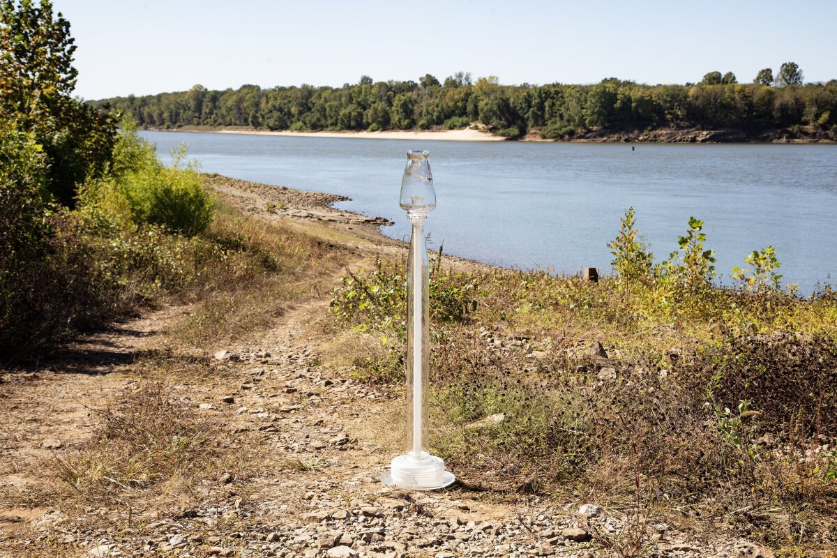
Wickliffe, Kentucky, July 17, 2020
36°57'52"N 89°05'39"W, Elevation 320 feet
Some of the tow boats moored here await repairs in the drydock on the Ohio River. Overlooking the river and the contemporary town of Wickliffe is a prehistoric, Mississippian archaeological site operated by the State of Kentucky. Native American people lived here from about 1100 to 1350 CE, building earthen mounds and permanent housing around an open courtyard. This ancient city, located three miles from the confluence of the Ohio and Mississippi Rivers, was active at the same time as the larger Cahokia Mounds site near Collinsville, Illinois and eleven miles from the confluence of the Missouri and Mississippi Rivers.
Ferry Road, West Paducah, Kentucky, July 16, 2020
37°08'23"N 88°44'43"W, Elevation 310 feet
The map labels this site adjacent to the bridge from Illinois as “Metropolis Ferry.” At one time, there may have been a ferry carrying passengers to Metropolis, Illinois on the other side of the Ohio river, but all that remains are two gravel roads leading to the river.

Joppa, Illinois, July 17, 2020
37°12'04"N 88°50'39"W, Elevation 310 feet
This Cairn is located about a mile upstream from the decommissioned Joppa power plant and remaining pools of toxic coal ash. Built in stages in the 1950s, the Joppa Generating Plant, a coal and natural gas electrical power plant is about thirty miles upriver from the Ohio River’s confluence with the Mississippi River at Cairo, Illinois, and fifteen miles from Paducah, Kentucky.
Environmental concerns for coal-burning plants include air and water pollution. Lung diseases and heart attacks caused by breathing toxic particles in the smoke. Leaking ponds of combustion waste, including arsenic and heavy metals, can pollute rivers and groundwater. Owned by Vistra Energy since 2018, the company announced in September 2020 that they will close this plant by the end of 2025, citing the expense of meeting EPA guidelines and the company’s goal of achieving net-zero carbon emissions by 2050. What will happen to those toxic waste pools when the plant is decommissioned?
According to the Environmental Protection Toxics Release Inventory, Joppa stored 366,675.30 pounds of coal ash in lagoons in just one year. Multiplied over the more than sixty years of operation, heavy metals would be abundant in those ponds.

Highway 51 bridge in the background, Near Cairo, Illinois
July 17, 2020, N37°04‘44“N, W89°11‘11“, Elevation 310 feet
Algae and small water plants near the shore form the backdrop for the Softserve Cairn, an assemblage of clear and translucent glass. This bank of the Cache River, between US Route 51 and Illinois Route 37 (also called old Us 57 and Ohio River Scenic Highway) is located one mile from the Ohio River. A quarter of a mile south of the cairn site, all that remains of the town of Golden Lily is one home at the Taylor Road intersection and a listing in the US Geological Survey Geographic Names Information System.

Bay City, Illinois, October 13, 2020
N37°15‘20“, W88°30‘14“, Elevation 320 feet
This cairn is located off Ohio highway 1, also called Ohio River Scenic Highway and Bay City Road. Bay City is notable only for the Bay City General Storethey have a little bit of everything, including shoe laces, powdered sugar doughnuts, and plumbing parts. The GPS tells us we are in Golcanda, a larger town eight miles away as the crow flies, but a much longer drive as the road follows Bay Creek before cutting north, parallel to the Ohio River.
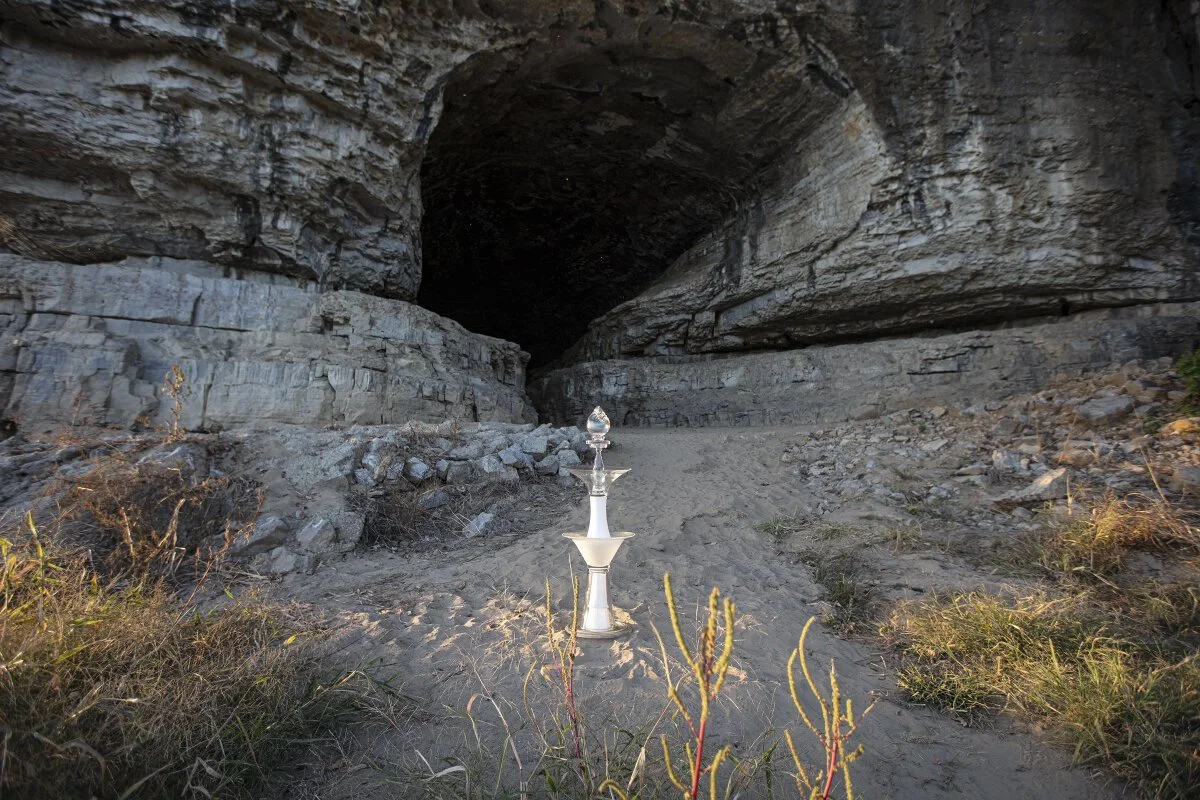
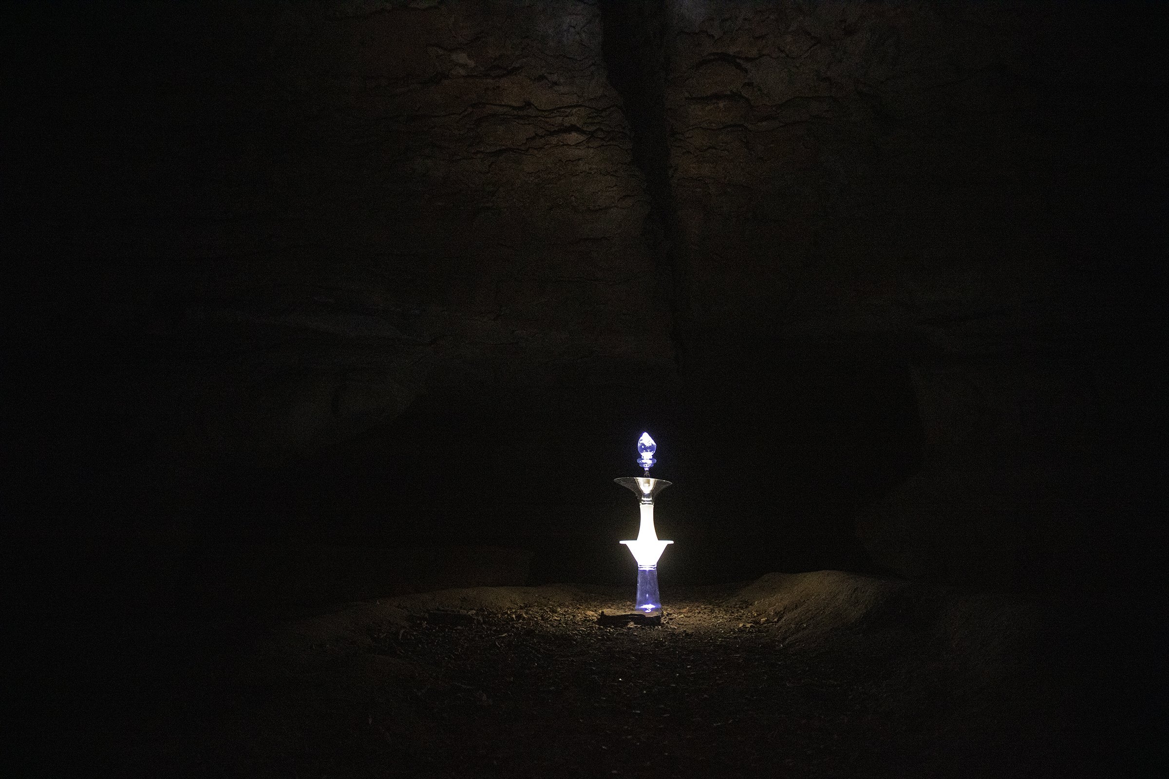
Cave in Rock State Park, Paducah, Kentucky, October 13, 2020
N37°28‘04“, W88°09‘36“, Elevation 310 feet
The entrance to this fifty-five-foot-wide cave overlooking the Ohio River is many steps down from the parking lot. It is definite worth the walk to see and possibly enter this natural “room,” that was carved by water thousands of years ago.

Confluence of the Wabash and Ohio Rivers, Old Shawneetown, Illinois, October 14, 2020
N37°41‘46“, W88°08‘04“, Elevation 370 feet
The red-topped cairn has been placed on top of a US Geological Survey marker imbedded in levee, looking down on Old Shawneetown. This largely abandoned town encapsulates the history of many river towns. Settlers arrived at the site of a Native American village, near the Wabash River’s confluence with the Ohio River, in 1798. The town was laid out in 1810 and quickly became an important commercial center and US Territory administrative center. In 1816, its bank was one of only two federally chartered banks in the United States. The bank shown in this image was built in 1836-41 and served for over a century until the 1937 Ohio River flood inundated the town, and the residents moved to higher ground.

Uniontown Warf, Uniontown, Kentucky, October 14, 2020
N37°46‘31“, W87°56‘19“, Elevation 340 feet
This cairn is resting on the Uniontown levee, built after the 1937 Ohio River flood to protect the town. Kentucky Route 130 passes through the town onto the levee. A caravan of semi-trucks, labeled with the names of local farms, await their turns to offload grain into waiting barges at the Uniontown Ferry Boat Dock.

Gallipolis, Ohio, October 18, 2020, N38°40‘50“, W82°11‘33“, Elevation 560 feet
The cairn, an aggregation of the Capacious and other cairn parts, stands watch over the Robert C. Byrd Dam. One of nineteen dams on the Ohio River, this one has not changed since it was dedicated in 1935. The locks are on the other side of the Ohio River in the village of Gallipolis Ferry, West Virginia. The name Gallipolis means city of the French, named for the first immigrant settlers who were fleeing the 1790 French Revolution.

Old Town Leavenworth, Indiana, October 15, 2020
N38°18‘03“, W86°19‘56“, Elevation 380 feet
This cairn is resting in the Ohio River near an abandoned three-story brick home in a park in Old Leavenworth. Like many other Ohio River towns, Leavenworth was inundated in the flood of 1937. This home may have been one of the casualties. Four of the town’s 418 people were evacuated in that flood. The 2010 census showed a population of 238 people. The 2020 census will show many of those people remained after the February 2018 Ohio River again rose to the rooftops of many homes. https://www.youtube.com/watch?v=4UcM8F6LcWQ

Oxbow Nature Conservancy, Lawrenceburg, Indiana
October 16, 2020
N39°05‘58“, W84°50‘29“, Elevation 460 feet
This clear-glass cairn rests at the eighth stop on the self-guided tour of the Oxbow Nature Conservancy, a 2500-acre spread of level river bottom that is the most important remaining wetland on the banks of the Ohio River. This site marks multiple confluences: not only is the area where the states of Ohio, Indiana, and Kentucky meet, it is located at what might be called a cultural confluence. The Conservancy, conceived by conservationists who formed Oxbow Inc. in partnership with Audubon of Ohio, is located behind the Hollywood Casino’s loading dock and 100 feet from the Archaeological Research Institute.

Off Otter Creek Road, Brandenburg, Kentucky, October 15, 2020
N37°57‘33“, W86°03‘08“, Elevation 370 feet
This mushroom-like cairn is posed on the rocky shore of the Otter Creek Recreation Area. Behind the camera, a man was fishing from the boat landing.

Louisville, Kentucky, October 15, 2020
N38°08‘52“, W85°54‘11“, Elevation 400 feet
It was dusk, and people were loading outboard pleasure boats onto trailers on the boat launch at Riverview Park when Watershed Cairns artists arrived. They found an out-of-the-way grove of trees overlooking the river where they setup the cairn and waited for darkness. Then, a few battery-powered lights in the tall cairn and along camera exposure illuminate the scene. The last light on the river is barely visible in the upper right of this image.

Clifty Falls State Park, Indiana, October 16, 2020
N38°45‘51“, W85°26‘03“, Elevation 800 feet
The Rectangle Cairn was assembled where stones were missing on the wall separating visitors from the canyon and Big Clifty Creek below. This deep valley was created thousands of years ago when the southward flowing waters of Clifty Creek met the newly formed Ohio River. There are several falls in the park, but none can be seen in this view. The largest is sixty feet tall.

Owensboro, Kentucky, October 14, 2020
N37°46‘42“N, W87°07’40“, Elevation 360 feet
A plastic cup found at the base of this concrete retaining wall forms the top of this simple cairn. Unfortunately, there is always plenty of trash on riverbanks and in parks. The people who left the trash may have the mistaken idea that it will wash away or dissolve. It will take 450 years for this cup to break down. Riverbeds that used to be sand and rocks are now covered in single-use plastics. As plastic breaks down, it doesn’t go way. Microscopic plastic particles are found in fish and in drinking water. Refuse to litter.

Riverfront Park, Ripley, Ohio, October 17, 2020
N38°44‘44“, W83°50‘28“, Elevation 490 feet
This large, rusting tank is hiding in the woods at the edge of Riverfront Park in Ripley, Ohio. Founded in 1804 by a veteran of the American Revolutionary War, Ripley became one of the first depots on the Underground Railroad. Both Black and white residents aided people who were escaping their enslavement in Kentucky.

Salt Lick Creek, Vanceburg, Kentucky, October 17, 2020
N38°36‘10“, W83°19‘18“, Elevation 480 feet
A decaying wooden bridge over Salt Lick Creek that flows from rural areas into the Ohio River at Front Street, the road that runs close to the river. There had been a First Street, but it was washed away when the 1937 flood filled the entire downtown. When rebuilding after the flood, residents renamed Second Street, Front Street.

Highway 23 Bridge, Portsmouth, Ohio, October 17, 2020
N38°43‘48“, W82°59‘56“, Elevation 520 feet
This cairn rests on the riverbank between the Chillicothe bridge, connecting Ohio and Kentucky, and the point where he Scioto River joins the Ohio River and marks a landmark that cannot be seen. The two-ton Indian Head Rock emerged on the Kentucky side of when the Ohio river was low. It was was believed to have been engraved with an ancient Native American pictograph, and marked by many people over the years. River pilots used to gauge the river’s depth since the 1802. Recent history revolves around its theft and relocation to a park on the Ohio side in 2007, and the legal battles between the two states that followed. The state of Kentucky won the suites and custody of the rock, placing it in storage, out of public view.

Forest Run Creek, Pomeroy, Ohio, October 18, 2020 39°02‘22“N 81°59‘59“W, Elevation 570 feet
Near the junction of highway 7a and Forest Run Road is the aptly named Dark Hollow Road. At dusk, this narrow, tree-lined country road seemed abandoned, and a little spooky. But that impression changed when a caravan of beautifully restored muscle cars drove past the site and pulled into a driveway just up the road.

Point Park, Little Kanawha River, Parkersburg, West Virginia
October 20, 2020, N39°15‘55“, W81°34‘03“, Elevation 580 feet
This cairn sits on the bank of the Little Kanawha River in Point Park, just a few feet from its confluence with the Ohio River in Parkersburg West Virginia. A railroad bridge and the State Highway 9 Bridge are in the background. A locked gate under the bridges leads to the Parkersburg Yacht Club, private homes with docks on the river along Levee Access Road.

Proctorville, Ohio, October 18, 2020
N38°26‘27“, W82°24‘13“, Elevation 520 feet
Many people use the Ohio river to boat and fish. Public river access is available in almost every town and at the end of many county lanes like this one at Old State Road/Highway 3. Adjacent to the dirt boat ramp, this big puddle suffers from an oil slick and is surrounded by trash.

Crown City, Ohio, October 18, 2020
N38°35‘59“, W82°13‘49“ Elevation 500 feet
The Rod Cairn stands among evenly spaced trees in this small plot. Gray clouds and rain complete the peaceful setting

Cottageville, West Virginia, October 18, 2020
N38°53'12" W81°50'23", Elevation 560 feet
Nightfall covered this tributary of Mill Creek during its journey from this site near Ripley Road to the main stem of Mill Creek. Mill Creek flows under State Highway 2, heading for the Ohio River. It almost reaches the river before making two hairpin curves to flow alongside the larger river for more than a mile, then it joins the Ohio downstream in the little town of Millwood.

Harmar Historic District, Marietta, Ohio, October 21, 2020
N39°24‘41“, W81°27‘29“, Elevation 590 feet
These timbers originally supported a covered bridge spanning the Muskingum River, separating Harmar and Marietta. In 1863, it was converted to an iron railroad bridge. The oldest swinging iron bridge in the country, this bridge has been rebuilt four times after floods. Limited to foot traffic in 1962 and now closed, there is a campaign to fund the bridge’s restoration.

Newport, Ohio, October 21, 2020
N39°23‘28“, W81°14‘43“, Elevation 600 feet
This cairn is posed across the Ohio River from the coal fired Municipal Power Plant in St. Marys, Ohio, built in the 1960s. A 2010 study by the Clean Air Task Force found that the soot and air-born pollutants coming from the St. Marys plant likely cause nine deaths, fourteen heart attacks, and one hundred and forty asthma attacks annually for residents. Like many coal-fired powerplants, St. Marys may be replaced by cleaner options. In 2016, the Army Corps of Engineers completed a hydroelectric powered plant at Willow Island Lock and Dam, about five miles downriver from St. Marys. The new plant will provide electricity with fewer risks to the public’s health.

Pike Road, St. Marys, Ohio, October 21, 2020
N39°23‘30“, W81°11‘34“, Elevation 840 feet
Bluffs are a significant piece of Ohio River geography and are frequently the site of early cemeteries. This forested area, identified as Old St Marys Pike Hill, includes a small, historic cemetery for the International Order of Odd Fellows, a fraternal organization. The cairn rests on a large tree stump, encrusted with moss and lichens.

Fly, Ohio, October 21, 2020
N39°33‘59“, W81°00‘11“, Elevation 590 feet
The cairn sits on the Ohio riverbank at the edge of the Wayne National Forest, in the village of Fly, Ohio. The Sistersville Ferry, one of the few ferries operating on the Ohio River, carries cars and passengers across to the larger town of Sistersville, West Virginia. The town is named for the sisters Sarah and Delilah Wells who owned the land on which the town was built. Their last name is preserved in nearby Wells Island, a part of the Ohio River National Wildlife Refuge.

New Martinsville, West Virginia, October 21, 2020
N39°38‘15“, 80°51‘34”, Elevation 610 feet
A small steady stream emerged from one of the culverts under this road, used by occasionally by cars and more frequently by hikers and runners in New Martinsville City Park.

Powhatan Point, Ohio, October 21, 2020
N39°51‘59“, W80°47‘33“, Elevation 620 feet
Powhatan Point marks the confluence of Captina Creek and the Ohio River. It provides a view of the many layers of sandstone formed when the Ohio River was created. the now-vanished Teays River became what is called the deep stage Ohio River. Then, about 100,000 years ago, the Wisconsin Glacier pushed the deep stage Ohio southward to create a channel similar the present Ohio River. If the glacier had not intervened, the modern state of Kentucky would have been larger and Ohio smaller.
https://ninenet.pbslearningmedia.org/resource/ket08.sci.ess.earthsys.ohioriver/how-the-ohio-river-was-formed.

Fork Ridge Road and 12th Street, Moundsville, West Virginia
October 21, 2020
N39°54‘44“, W80°43‘42“, Elevation 640 feet
The city of Moundsville is named for the nearby sixty-foot-tall Grave Creek Mound, one of the largest conical-type burial mounds in the United States The compacted soil mounds were built in 250–150 BCE by members of the Adena culture. This much smaller, contemporary mound of used paving material marks the end of a road adjacent to city sports fields. https://upload.wikimedia.org/wikipedia/commons/e/ef/Grave_Creek_Mound.jpg

Wheeling Creek at Fulton and Fawn Streets, Wheeling, West Virginia, October 22, 2020
N40°04‘28“, W80°42‘29“, Elevation 640 feet
Wheeling, West Virginia is a dense urban area. Highways were under construction everywhere. From the parking lot behind small restaurants and businesses, layers of highways and exit ramps were being built next to and over Wheeling Creek

Blum Park, Steubenville, Ohio, October 22, 2020
N40°21‘51“, W80°36‘33“, Elevation 650 feet
Watersheds are revealed not only in large-scale water bodies like rivers, streams, wetlands but also in small scale such as rainwater flowing dow

County road 17a under the Ohio River Scenic Byway, Rayland, Ohio, October 22, 2020
N40°12‘53“, W80°39‘60“, Elevation 650 feet
Railroad tracks run parallel with the river and cross under the Ohio River Scenic Byway at this site.

Tomlinson Run Park, New Cumberland, West Virginia, October 22, 2020, N40°32‘24“, W80°35‘06“, Elevation 890 feet
People who like to fish and hunt waterfowl frequent the quiet waters of Tomlinson Lake on the Ohio River.This lake is in the wilderness area of Tomlinson Run State Park, West Virginia’s “top” 1,398-acre park.

Grimm’s Bridge Road, Fredericktown, Ohio, October 22, 2020
N40°40‘53“, W80°32‘06“, Elevation 710 feet
The shadows formed by these trees beside Grimms Bridge Road, parallel with the Little Beaver Creek, reach out to frame the cairn. Two hundred yards upstream, all that remains of the road’s namesake is an overgrown road leading to some large pieces of concrete on the bank.

Riverfront Park, Rochester, Pennsylvania, October 22, 2020
N40°41‘54“, W80°16‘52“, Elevation 680 feet
The town that would eventually be called Rochester was settled by European immigrants at a Lenape village named Sawcunk. A century later, it was the home to the National Glass Company that developed an innovative industrial process for creating glass objects. A similar mold process was used to make the household glass assembled in this cairn. In the image, a man and his young daughter are fishing from the pier, and pleasure boats travel on the Ohio River as the sunset turned the smoke from Steubenville, Ohio, factories a rusty orange color.
Cottageville, West Virginia, October 18, 2020, 38°53‘12“N 81°50‘23“ W, Elevation 560 feet
Nightfall covered this tributary of Mill Creek during its journey from this site near Ripley Road to the main stem of Mill Creek. Mill Creek flows under State Highway 2, heading for the Ohio River. It almost reaches the river before making two hairpin curves to flow alongside the larger river for more than a mile, then it joins the Ohio downstream in the little town of Millwood.

Point of View Park, Pittsburgh, Pennsylvania, October 21, 2022 N40°26'21.8", W80°1'17", Elevation 1170 feet
Resting among native plants at the bluff’s edge, the rectangular glass cairn mirrors the shape of buildings on the Pittsburgh skyline. Below, Point Park marks the confluence of the Alleghany and Monongahela Rivers to become the Ohio River from this point until it merges with the Mississippi River at Cairo, Illinois. The name Ohio comes from the Seneca people’s word meaning “beautiful river.” Unfortunately, as a result of heavy industrial and urban waste flowing into the water for more than a century, the Ohio is now the most polluted river in the United States.

Highway 105 and Elm Street, Cloverport, Indiana, October 15, 2020, N37°49‘22“, W86°37‘08”, Elevation 340 feet
The Quiver Cairn rests at the edge of the Elm Street Boat Launch. Its shape and golden spirals mirror the early fall color in the trees beside the highway 105 bridge.

John James Audubon State Park, Henderson Kentucky, October 14, 2020, N37°52‘44“, W87°33‘37“, Elevation 410 feet
The John James Audubon State Park, one mile from the Ohio River, including a 300-acre old-growth forest conservation area, honors the painter and naturalist who lived Henderson, Kentucky, from1810–1819. Construction of the park by the Civilian Conservation Corps began in the 1930s. The Scenic Lake is one of the two lakes they created by draining the swamps that covered much of the land. The John James Audubon Museum, located in the park, contains his famous Birds of America prints, along with various paintings and artifacts.

Charlestown State Park, Charlestown, Indiana, October 16, 2020, N38°24‘02“, W85°37‘53“, Elevation 420 feet
This cairn sits at the edge of a four-lane boat ramp in Charlestown State Park. The park was created in 1996 on land that had been the Indiana Army Ammunition Plant and Rose Island, a popular recreation area from the 1800s. In the 1920s, Rose Island became an amusement park, complete with a small zoo, merry-go-round, roller coaster, and more until it was destroyed in the Ohio River flood of 1937.

Overlooking the Newburgh Locks and Dam, Indian Trail Overlook Park, Newburgh, Indiana, October 14, 2020, N37°56‘03“, W87°22‘26“ , Elevation 450 feet
The Indian Trail Overlook Park, off Indiana Route 66 and French Island Trail, provides a view of the Newburgh Locks and Dam, built by the US Army Corps of Engineers in the 1970s to replace an older dam. The park is also home to some beautiful old trees. The Mushroom Cairn draws attention, not to the dam, but to the base of one of these grandmother trees. Her ability to draw water and nutrients from the earth to feed its oxygen generating factories—leaves, is worth celebrating.

Indian Trail Overlook Park, Newburgh, Indiana, October 14, 2020, N37°56‘03“, W87°22‘26“, Elevation 450 feet
The Indian Trail Overlook Park, off Indiana Route 66 and French Island Trail, provides a view of the Newburgh Locks and Dam, built by the US Army Corps of Engineers in the 1970s to replace an older facility. The park is also home to some beautiful old trees. The Mushroom Cairn draws attention, not to the dam, but to the base of one of these grandmother trees. Her ability to draw water and nutrients from the earth to feed its oxygen generating factories—leaves, is worth celebrating.

Golcanda, Illinois, October 13, 2020, N37°22‘02“, W88°28‘56“, Elevation 330 feet
Behind this cairn on the riverbank in Golcanda, Illinois, a concrete and stone tower marks the point where Lusk’s Creek enters the Ohio River. Across the creek the historic Lusk Ferry had been moored at the present location of the Golcanda Marina. Before there was a bridge, this ferry carried passengers and freight across the river and played a tragic role in the Trail of Tears story. In the winter of 1838, thirteen thousand Cherokee, who had been expelled by the federal government from their traditional homes in the East, were forced to walk to the Oklahoma territory. They arrived cold and starving, on the Kentucky side of the river. The ferry’s owner made the people to wait through the night huddled under Mantle Rock. Many died from the cold, others were murdered. The next afternoon, those who had survived were charged eight times the usual fee to ride the ferry across the river.

River Road, Grandview, Indiana, October 14, 2020
N37°56‘11“, W86°57‘48“, Elevation 370 feet
Looking toward the two-unit coal-fired Rockport Power Generating Plant, built in the late1980s.The plant operated by American Electric Power (AEP) is one of the largest coal-fired plants ever built.
In July 2019, AEP announced it would retire its Rockport Unit 1 by the end of 2028 as part of a U.S. District Court-approved modified consent decree concerning air pollution from multiple AEP plants in the Midwest. The website S&P global reported that AEP expects the share of coal-fired generation in its portfolio to drop about 36% by 2030, with solar, hydro and wind up 29%

Cave in Rock State Park, Paducah, Kentucky, October 13, 2020 N37°28‘04“, W88°09‘36“, Elevation 310 feet
Entering the cave at dusk, it was easy to imagine how our ancestors may have used this space for shelter. A beam of light entered from a hole in the ceiling. The artists struggled to build a level cairn on the uneven rocks before the sun set, but ultimately relied on three small LED lights for illumination. After the photo was made and the glass packed, those same lights guided them out of the cave and up the many steps to the parking lot in the pitch-dark.

Bay City, Illinois, Barren Creek meets the Ohio River, October 13, 2020, N37°15‘18“, W88°30‘16“, Elevation 320 feet
While sturdy enough to walk on and place the Rod Cairn between the upright poles on the edge of this dock on Barren Creek, the slanting deck is disorienting. Adding to the confusion, while the latitude and longitude on the GPS app remained the same, the physical location kept switching between Illinois and Kentucky. Further study of the maps revealed that because the Ohio River channel had changed over time, the boundary of the two states was very close to Ohio at this point, rather than in the middle of the river where it had been when the state boundaries were determined.

Water Intake, Paducah, Kentucky, October 13, 2020 N37°05‘48“, W88°36‘36“ , Elevation 330 feet
Other than a well-kept downtown riverfront park with dozens of beautifully painted murals portraying the city’s history, much of the Paducah, Kentucky riverfront is devoted to commercial and industrial property. One exception is the municipal water intake. The building’s sign reminds us that “raw water” is pumped from the Ohio River and treated for drinking by more than 27,000 customers in Paducah, McCracken County, and parts of Graves and Marshall Counties. Not everyone can take tap water for granted, however. A note on the utility’s website announced that they would begin turning off water service to households with past-due water bills.

Carmeuse Natural Chemicals Plant, Butler, Kentucky, October 17, 202, N38°50‘06“, W84°14‘31“, Elevation 760 feet
Highway 8, also called the Mary Ingles Highway, closely follows the Ohio River. The Carmeuse Natural Chemicals Plant utilizes rock and aggregate from local mines to make concrete and in road construction. Located on the banks of the Ohio River, it ships most of its product on river barges.

Eden Riverfront Park, Cincinnati, Ohio, October 17, 2020 N39°07‘03“, W84°29‘12“, Elevation 760 feet
From the overlook at Eden Riverfront Park, a few miles north of downtown Cincinnati, this cairn stands watch over the city.

Greenup, Kentucky, October 17, 2020, N38°34‘31“, W82°49‘54“, Elevation 520 feet
The cairn is posed in the Greenup City Park between Main Street and the Ohio River. Northwest of the park, Main Street Bridge crosses the Big Sandy River as it joins the Ohio.

Marina Park, Wheeling Island, Wheeling, West Virginia, October 22, 2020, N40°04‘37“, W80°44‘13“, Elevation 660 feet
Three bridges connect this most densely populated island in the Ohio River with the rest of the Wheeling, West Virginia and Bridgeport, Ohio. Although the southern tip of the island is occupied by a casino, racetrack, and stadium, most of the island is residential with closely spaced, two- or three-story frame homes on narrow streets. The cairn is posed in a riverfront park on the northwestern side of the island that seems to be the neighborhood’s back yard with many people strolling, walking their dogs, and children playing.

Kenova, West Virginia, October 18, 2020
N38°24‘51“, W82°35‘36“, Elevation 530 feet
West Virginia’s Big Sandy River enters the Ohio River at Kenova. Located near the tristate boarder, the town’s name is a combination of the names of Kentucky, Ohio, and West Virginia. Part of the larger Ashland Metropolitan area, Kenova’s distinction is its Dreamland Pool; it was the largest pool east of the Mississippi when it opened in 1926.
Under Highway 79 exit ramp, Glenfield, Pennsylvania, October 23, 2020, N40°31‘06“, W80°07‘51“, Elevation 850 feet
Near the city of Pittsburgh, a web of highways, streets, and private property impede access to the Ohio River or its tributary streams. One exception is a small commuter parking lot under a Highway 79 exit ramp. The steep rock and gravel slope under the highway structure provides a view of an idyllic stream almost unchanged by urban sprawl.