

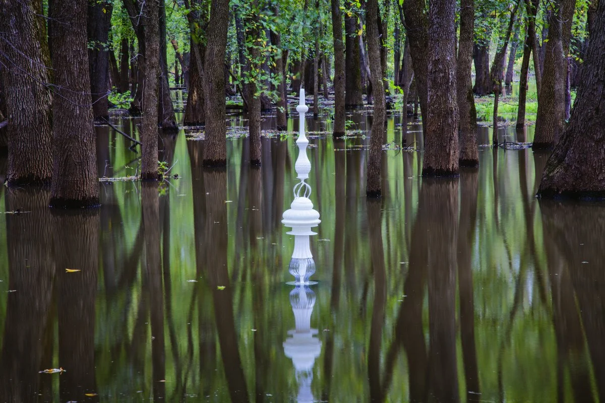
Alma Marina, City of Alma, Wisconsin—June 8, 2016
44° 20’ 27.46”N 91° 55’ 56.14”W Elevation 667 feet
The cairn glows on the riverbank as the sun sets on the Upper Mississippi River Natural Wildlife and Fish Refuge.

Stump Lake, Minnesota—June 14, 2016 47° 29’ 20”N 94° 45’ 21”W Elevation 1,350 feet
A version of the White Pointer cairn stands next to birch trees, common in northern Minnesota.
More info

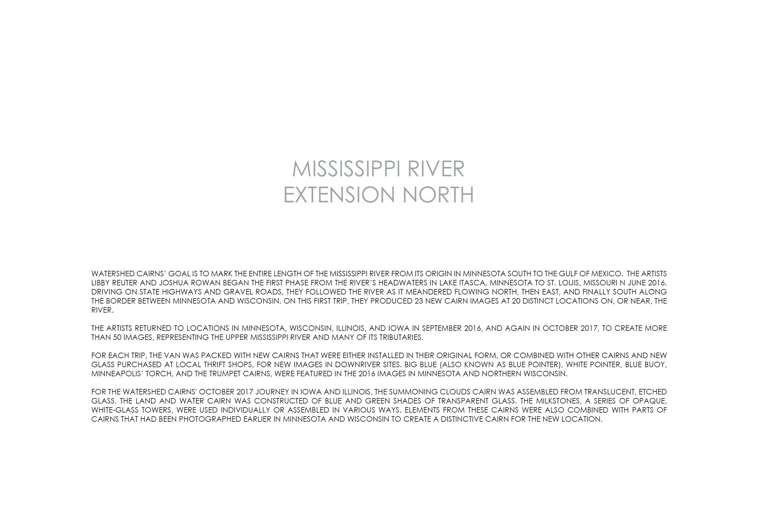
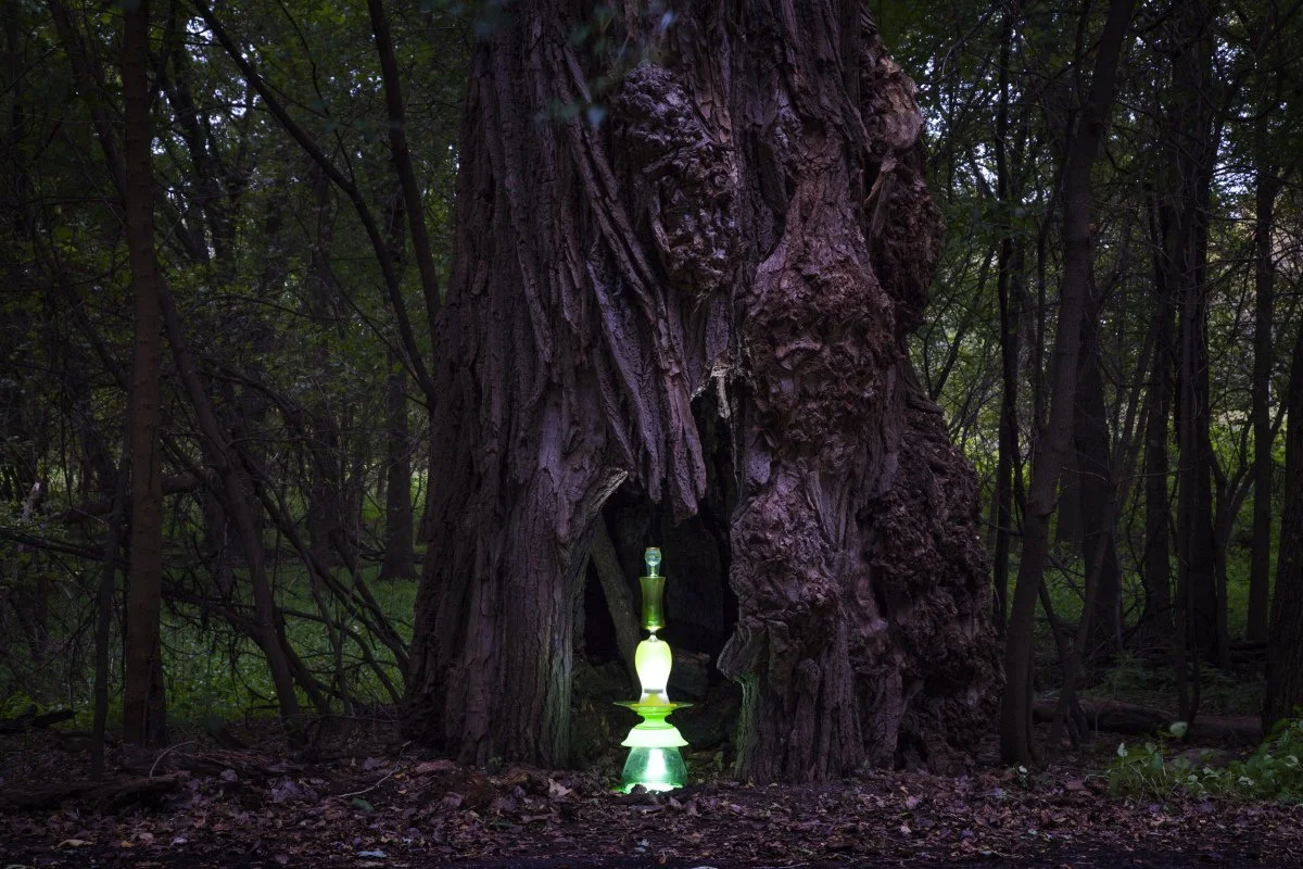
Little Rock Lake, Watab, Minnesota—June 11, 2016 45° 42’ 19”N 94° 10’ 35.12”W Elevation 1,040 feet
The ground is soft under this cairn, poised in a bog off Hemlock Road NW.
La Salle Lake Scientific and Natural Area, Minnesota—June 13, 2016
47° 12' 33.336"N 95° 6' 35.8194”W
The name Coffee Pot Landing comes from the brown hue of the water, caused by the nearby bogs and iron in the surrounding soil.

Brooklyn Park, Minnesota—June 15, 2016 45° 08’ 32”N 93° 18’ 43”W Elevation 830 feet
The cairn is dwarfed by the electric transmission towers across the Mississippi River. They carry electricity generated by the Coon Rapids Dam, located a few hundred feet upstream of this site.

Brooklyn Park, Minnesota—June 15, 2016 45° 08’ 32”N 93° 18’ 43”W, Elevation 830 feet
A hybrid cairn, assembled from parts of the Blue Boy and Pointer cairn, sits on rocks in front of exposed tree roots, below the Coon Rapids Dam

Crow Wing State Park, Brainerd, Minnesota—June 11, 2016 46° 9' 39.3834"N 94° 12' 22.068"W, Elevation 1,214 feet
The Blue Buoy cairn makes an appearance at the confluence of the Crow Wing and Mississippi rivers, on the group campground’s shoreline in Crow Wing State Park.

Leech Lake Indian Reservation, Chippewa National Forest, Minnesota—June 15, 2016 47° 15’ 03”N 94° 13’ 17”W Elevation 1,297 feet
The “ground” on which the cairn rests in a wetland is a raft of grass, moss, and decaying plants, floating on shallow brackish water.

Great River Bluffs State Park, Minnesota—June 9, 2016 43° 56' 30.25"N 91°23’ 9.26W, Elevation 1,205 feet
Photographed on a bluff north of La Crescent, Minnesota. The town of Holland, Wisconsin, can be seen across the Mississippi River.

Merrick State Park, Fountain City, Wisconsin—Sept. 26, 2016, 44° 08’ 59”N 91° 44’ 56”W, Elevation 850 feet
This stonewall overlooks Lake Pepin apart of the Upper Mississippi River National Wildlife and Fish Refuge. The Mississippi River is home to many species and is an important bird migration route.

Merrick State Park, Fountain City, Wisconsin—Sept. 26, 2016
44° 08’ 59”N 91° 44’ 56”W, Elevation 654 feet
Latsch Island, tucked under the Mississippi River bridge connecting Minnesota and Wisconsin, is home to dozens of small floating homes.

Warrentown, Wisconsin—September 27, 2016
44° 33’ 31.56”N 92° 18’ 34”W, Elevation 690
High water on the Rush River near its confluence with the Mississippi River separates the Blue Pointer cairn from the boat dock. The birds on the dock don’t seem to mind being rocked by the waves.

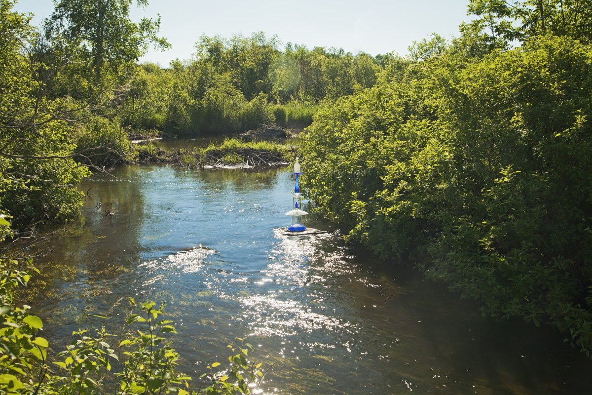
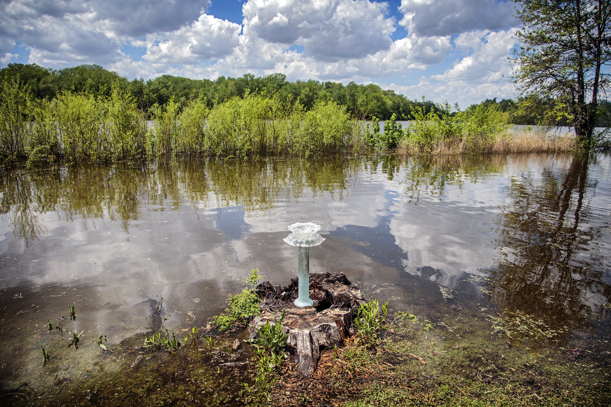
South of Hastings, Minnesota—September 27, 2016
44° 39’ 58”N 92° 44’ 10”W, Elevation 840 feet
The cairn points north in the flooded woods close to the Highway 58 bridge over the Vermillion River, near Prairie Island.
South of Hastings, Minnesota—September 27, 2016
44° 39’ 58”N 92° 44’ 10”W, Elevation 734 feet
The White Pointer cairn appears to float on the reflective surface of the floodwaters in the riparian woodland, near the highway 58 Bridge spanning the Vermillion River.

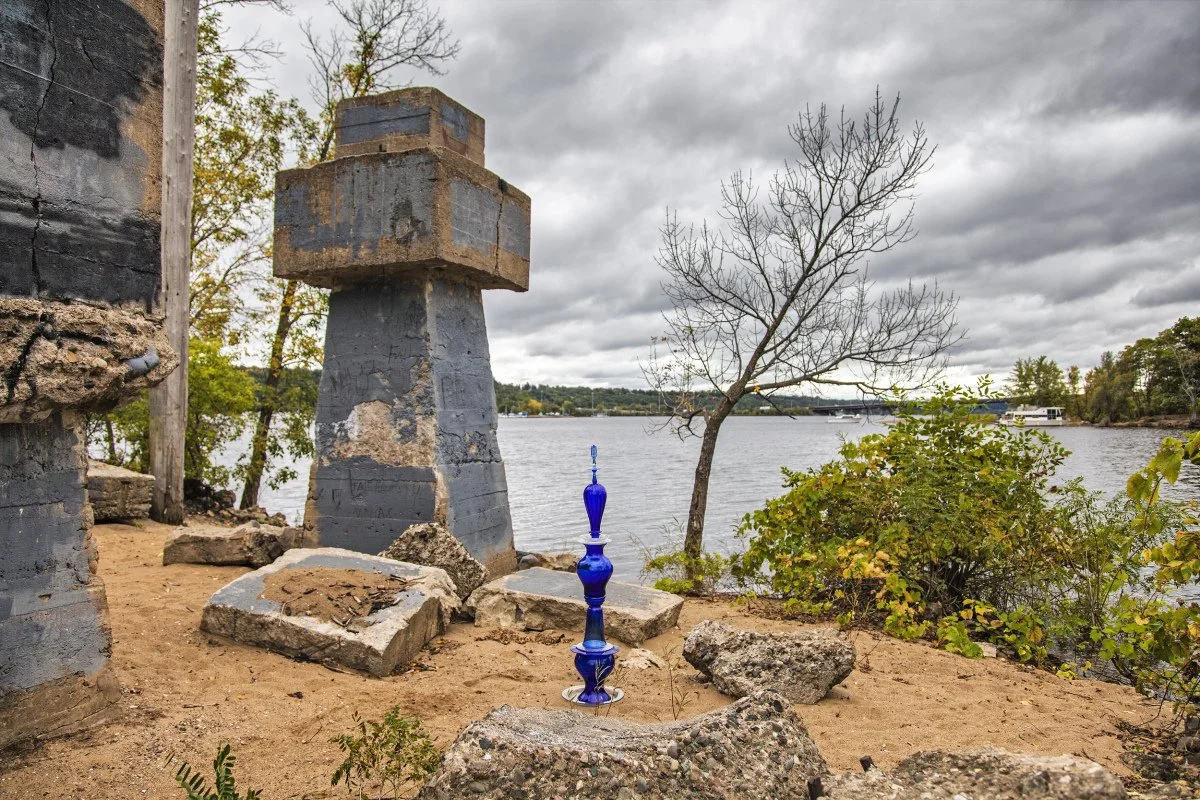
Carmichael Road, Hudson, Wisconsin—September 28, 2016
44° 56’ 48”N 92° 43’ 37”W, Elevation 820 feet
At this vacant greyhound racing park, the Trumpet cairn marks a parking lot the size of six football fields where rain can not soak into the ground.
Walnut St. Causeway, Hudson, Wisconsin—September 28, 2016 44° 58’ 17”N 92° 46’ 02”W, Elevation 720 feet
The concrete pillars are the remnants of Hudson’s Highway 12 toll bridge that carried traffic over the St. Croix River between Minnesota and Wisconsin.

Minnehaha Regional Park, Minneapolis, Minnesota—September 28, 2016, 44° 54’ 56”N 93° 12’ 36”W, Elevation 760 feet
The Big Blue cairn stands in front of Minnehaha Falls. The name of the falls comes from Native American words meaning waterfall.

Minnehaha Regional Park, Minneapolis, Minnesota, September 28, 2016 44° 54’ 54”N 93° 12’ 31”W, Elevation 760 feet
Trails lead alongside the river, downstream from Minnehaha Falls to this stone bridge where the Big Blue cairn stands sentinel.

Fort Snelling State Park, St. Paul, Minnesota—September 28, 2016, 44° 53’ 19”N 93° 11’ 03”W, Elevation 740 feet
The Traveling cairn rests in a field of 5-foot-tall yellow flowers. The Highway 55 bridge leading to Mendota Heights is in the background.
Fort Snelling State Park, St. Paul, Minnesota—September 28, 2016, 44° 53’ 01”N 93° 10’ 57”W, Elevation 760 feet
The Traveling Cairn nests in a 200-year-old, 7-foot diameter hollow tree that may have witnessed some dark aspects of American history. In 1824, the U.S. Army established a military outpost at the confluence of the Mississippi and Minnesota Rivers, near an Ojibwa sacred site and a multiethnic trading post. Military officers and fur traders stationed at Fort Snelling enslaved people of African descent, including Dread Scott who unsuccessfully sued for his freedom in 1857. Native people did not fare well, either. One thousand-six-hundred Dakota who had resisted expulsion from their homeland were held prisoner in harsh conditions through the winter of 1862. Many people died. In the spring, the survivors were taken to a barren part of the Dakota Territory.

St. Anthony Falls, Minneapolis, Minnesota—September 29, 2016 44°58' 36"N 93°15' 20"W, Elevation 1,280 feet
The Torch cairn rests beside the Mississippi River the Anthony Falls Historic District in downtown Minneapolis. This natural area had been the site of many grain mills that used the water power generated by the St. Anthony Falls in the 1800s. In the 1950 a series of locks and dams were built to extend navigation upstream.

St. Anthony Falls, Minneapolis, Minnesota—September 29, 2016 44°58' 53"N 93°15' 13"W, Elevation 760
The Torch cairn marks the remnants of an old mill that was constructed in the 1800s to use water from St. Anthony Falls for power.

Wyalusing State Park, Woodman, Wisconsin—September 29, 2016, 42° 59’ 37”N 91° 07’ 21”W, Elevation 1,130 feet
The Wisconsin River joins the Mississippi River in the distance—less than two miles from the overlook where the Big Blue cairn was balanced. Immediately after this photograph was made, a gust of wind toppled the cairn. We picked up every glass fragment.

Mines of Spain State Recreation Area, Dubuque, Iowa—September 29, 2016 42° 27’ 49”N 90° 38’ 14”W, Elevation 650 feet
The Trumpet cairn rests on a rock outcropping, overlooking this dry stream bed, or coulee, in the Mines of Spain State Recreation Area.

Apple River, Hanover, Illinois—September 30, 2016 42° 15’ 26”N 90° 17’ 11”W, Elevation 640 feet
The White Pointer cairn is balanced on the edge of a concrete retaining wall, overlooking the natural spillway in the town of Hanover, Illinois.
Lake Itasca State Park, Minnesota—June 13, 2016
47° 14’ 20.46”N 95° 12’ 35.18”W, Elevation 1240 feet
The Blue Buoy cairn is viewed from the hiking trail bridge, just downstream from Lake Itasca, visible in the background. At the Headwaters, the Mississippi River is shallow enough for children to wade in and chase the abundant minnows. To give you a better idea of the water’s depth, the cairn is installed on an inverted 18” tall plastic storage tub.

Lake Itasca State Park, Minnesota—June 13, 2016
47° 14’ 23”N 95° 12’ 28”W, Elevation 1,240 Feet
The Blue Buoy cairn sits at the point where the Mississippi River emerges from Lake Itasca as a small stream.
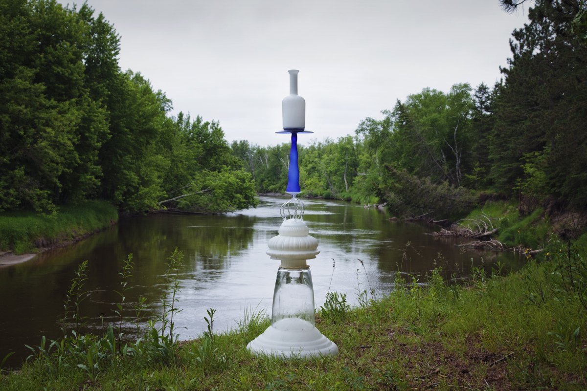
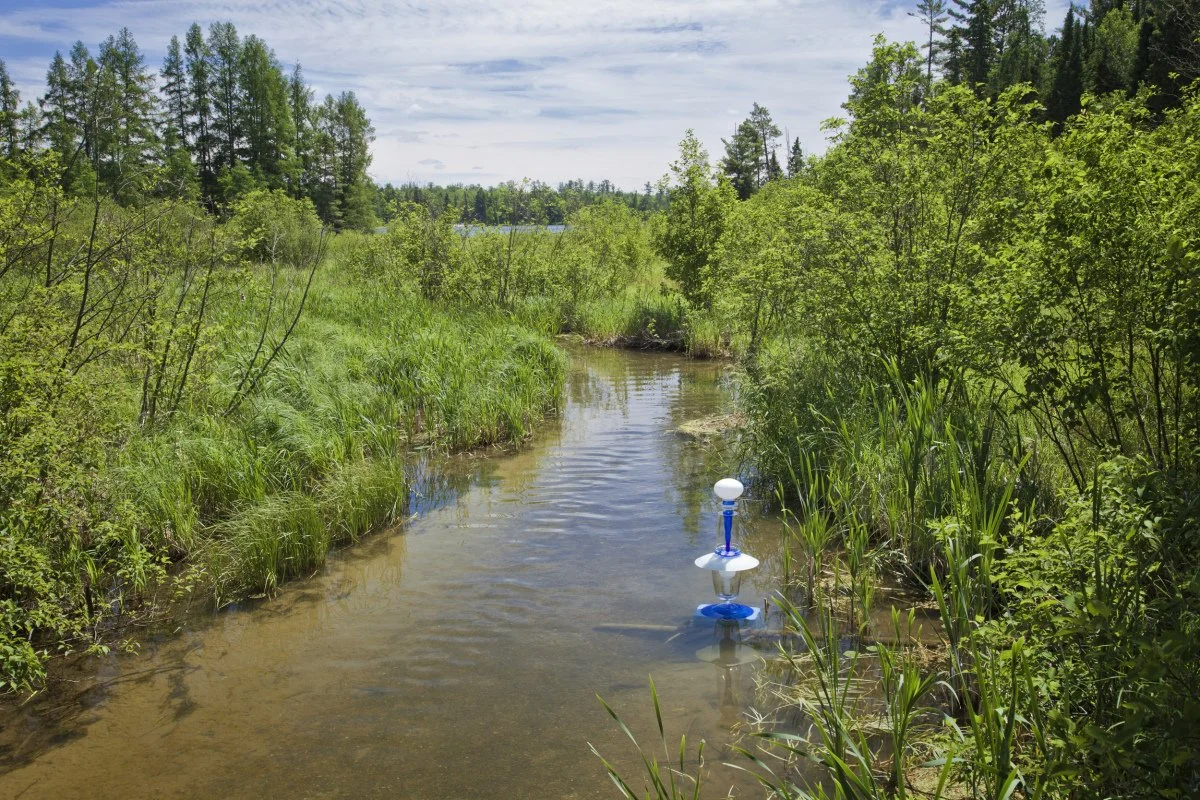
Jacobson Campground Road, off Highway 10 Ball Bluff, Jacobson, Minnesota—June 11, 2016 47° 0’ 56”N 93° 16’ 15”W, Elevation 1,260 feet
The curves of this cairn’s blue glass are no match for the twists of the Mississippi River, south of Grand Rapids, Minnesota.

Pettibone Park, La Cross, Wisconsin—June 16, 2016 43° 48’ 58”N 91° 15’ 54”W, Elevation 650 Feet
Nature is found in surprising places. This tranquil pond is found in Pettibone Park beneath the Mississippi River bridge connecting towns in Minnesota and Wisconsin. When looking up, you can see trucks, school busses, and cars speeding by on Highway #14.

Hok-Si-La City Park and Campground, Lake City, Minnesota—June 9, 2016 , 44° 28’ 12.26”N 92° 17’ 36.03”W, Elevation 807 feet
This cairn is situated in a swamp along the entrance to Hok-Si-La, a city park and campground on Lake Pepin.

National Forest Road No.3778, off Winnie Road NE, Minnesota—June 14, 2016 47° 23’ 56”N 94° 18’ 38”W, Elevation 1,310 feet
A Mississippi River Trails marker leads to this location where the Mississippi River enters Lake Winnibigoshish.

Lynxville, Wisconsin—June 16, 2016
43° 14’ 47.88”N 91° 03’ 29.42”W, Elevation 617 Feet
These old docks have been replaced by a larger, more modern harbor on the other side of the Great River Road in Lynxville, Wisconsin.

River Bluffs Regional Park, St. Cloud, Minnesota—June 15, 2016 45° 30’ 19”N 94° 08’ 37”W, Elevation 970 feet
A long winding road takes you to this regional park. From the parking lot, a path leads to a bridge overlooking this small stream. The cairn points to the mighty Mississippi River at the top of the image.

Northeast of the Minnesota Marine Art Museum, Winona, Minnesota—June 8, 2016, 44° 04’ 23”N 91° 40’ 37”W
Directions to this site west of downtown Winona, Minnesota, describe how natural beauty is hidden/preserved in the contemporary towns and cities.

Bulger’s Hollow Recreation Area, Clinton, Iowa—October 16, 2017, 41° 56’ 04”N 90° 10’ 55”W, Elevation 580 feet
The Land and Water Cairn sits among the golden lily leaves that wave in the wind. Some Iowans have expressed concern that these water lilies are appearing in more places on the river, but in a 2013 blog, D. Allen Pattillo, a research and extension specialist for Illinois State University wrote, “Aquatic plants are critical habitat areas for juvenile fish and aquatic insects and are natural nutrient filters, which is very good for the water quality.”

Sabula, Iowa—October 16, 2017
42° 0’ 48”N 90° 10’ 11”W, Elevation 790 feet
This ornamental grass and the trees behind it are part of a healthy riparian area separating the nearby cornfields from the Mississippi River. Riparian zones are important to people and the environment because they conserve soil, promote habitat diversity that support animal and aquatic ecosystems.

Black Hawk State Historic Site, Rock Island, Illinois—October 16, 2017, 41° 27’ 50”N 90° 34’ 0”W, Elevation 550 feet
This site is less than 3 miles from where the Rock River becomes part of the Mississippi River. The setting sun at the Blackhawk State Historic Site in the Black Hawk State Forest illuminates this cairn, turning it into a beacon of light at the water’s edge.

North of Savanna, Illinois—October 16, 2017
42° 08’ 26”N 90° 09’ 52”W, Elevation 780 feet
A Milkstone cairn overlooks the Lazy River Marina on the Mississippi River below the Mississippi Palisades State Park.

Mississippi Palisades State Park, Illinois—October 16, 2017
42° 07’ 23”N 90° 09’ 18”W, Elevation 660 feet
The Land and Water cairn rests in manmade rock arch at the base of a natural cliff in Mississippi Palisades State Park.

Rock Island, Illinois—October 17, 2017
41° 29’ 24”N 90° 36’ 02”W, Elevation 570 feet
After flowing east across Illinois from Rockford, the Rock River joins the Mississippi near this wetland where a flock of pelicans swam just out of view.

Twin Rivers Drive, Keokuk, Iowa—October 17, 2017
40° 23’ 13”N 91° 25’ 55”W, Elevation 480 feet
At sunset, the Summoning Clouds Cairn stands in the mud of this junkyard that smells of gasoline, oil, antifreeze, and rot. This collection of trashed cars and appliances is located fewer than 500 feet from the Des Moines River and less than a mile from the place where that river flows into the Mississippi River. Fifty million people get their drinking water from this river system. Should we care that it may be contaminated?

Wildcat Den State Park, Muscatine County, Iowa—October 16, 2017, 41° 28’ 01”N 90° 52’ 07”W, Elevation 560 feet
The Summoning Clouds cairn sits on a small island in Pine Creek just downstream from the restored historic mill in Wildcat Den State Park.

Wildcat Den State Park, Rock Island, Illinois—October 17, 2017
41° 28’ 01”N 90° 52’ 07”W, Elevation 560 feet
The Summoning Clouds Cairn rests on a small island in Pine Creek just downstream from the restored mill in Wildcat Den State Park. The park is known for its hiking trails with beautiful views of the rock bluffs.

Blackhawk Bottoms and, off Summer Road,Burlington, Iowa
October 18, 2017, 40° 43’ 57” N 91° 08’ 31” W, Elevation 580 feet
A small sign marked this area as Public Hunting Land. Watershed Cairns marked this area near the Skunk River’s confluence with the Mississippi River with two Milkstone Cairns. One cairn is standing upright in the hollow of a tall tree stump, and a second cairn is resting on the ground near the stump, mirroring the fallen tree in the background. The water in the distance is Patterson Lake, part of the Skunk River Slough.

Stump Lake fish and Waterfowl Management Area
Stump Lake Road, off Highway 100, near Fieldon, Illinois,
May 8, 2018, 39° 01’ 10” N90° 33’ 53” W, Elevation 430 feet
The remnants of homemade solar-powered lights on these docks suggest that this is a popular night-fishing spot near the Mississippi and Illinois RIvers. Milkstone Cairns sit on the docks in place of the fishermen.

Looking West, Highway 2 and Gresham Hollow Road, near Hamburg, Illinois, May 8, 2018
39° 13’ 13” N 90° 42’ 28” W, Elevation 450 feet
The Blue 2Lip Cairn rests on the sandstone creek bed under the Highway 2 bridge. Downstream, the creek flows into the Mississippi River at Gresham Hollow Park.

Looking East, Highway 2 and Gresham Hollow Road, near Hamburg, Illinois, May 8, 2018
39° 13’ 13” N 90° 42’ 28” W, Elevation 450 feet
The Blue 2Lip Cairn rests on the gravel part of a creek bed under the Highway 2 bridge, near Hamburg, Illinois, and across the Mississippi River from Elsberry, Missouri. This view is looking west/upstream toward an abandoned one-lane bridge.
Behind the camera, the creek flows west for less than a mile to join the Mississippi River at Gresham Hollow Park.

Summer and North Section streets, Hannibal, Missouri, May 9, 2018, 39° 42’ 59” N 91° 22’ 08” W, Elevation 690 feet
Riverside Cemetery (also called Riverview) overlooks the Mississippi River in the older part of Hannibal, Missouri. This old, but well-maintained, burial ground includes the grave of Jacob P. Beckley (1867–1918) who played Major League Baseball from 1888–1907 as a first baseman for the Cincinnati Reds and the St. Louis Cardinals; he was inducted into the Baseball Hall of Fame in 1971.
On the Mississippi River, south of Cedar Creek
Bob Bangert Park, Quincy, Illinois, May 9, 2018
39° 57’ 32” N 91° 25’ 08” W, Elevation 510 feet
The base of the Penstemon Cairn balances on a waterlogged stump at Bob Bangert Park on the Mississippi River in Quincy, Illinois. The park is near to Cedar Creek’s link with the great river.
The fluffy clouds above the river illustrate a vital part of the water cycle: water evaporates from rivers, wetlands, oceans, and lakes to later condense into clouds and fall as rain, nourishing crops and replenishing those same bodies of water.

Water Street, Hamburg, Illinois, May 8, 2018
39° 13’ 53” N 90° 43’ 04” W, Elevation 450 feet
A silver sunset provides the background for the Hummingbird Cairn in the pretty little town of Hamburg, Illinois. The road that becomes Water Street runs parallel to the river, with elevated beach houses on either side. This cairn rests on the riverbank near the town’s main intersection and the only stop sign we encountered for miles.

Across the River from Elsberry, Missouri, May 8, 2018Local Road 200N, off Mississippi River Road, near Hardin, Illinois
39° 09’ 47” N 90° 41’ 56” W, Elevation 450 feet
The Penstemon Cairn sits in Mississippi River water that has flooded the River Road. The cairn is inspired by the Penstemon genus of Midwest native plants, which are related to the popular foxglove garden plants. Hummingbirds, butterflies, moths, bees, and insects are attracted to the nectar of the frilly two-inch flowers on pale green stems. Some of the Penstemon species are endangered or no longer found in parts of the Midwest. Source: The Midwestern Native Garden: Native Alternatives to Nonnative Flowers: An Illustrated Guide, by Charlotte Adelman and Bernard L. Schwartz.

Near Warsaw, Illinois, May 9, 2018
40° 18’ 18” N 91° 25’ 58” W, Elevation 480
An unusual cloud hovers over the Hummingbird Cairn perched on an overgrown flowerbed in front of an old brick silo on the farm near Warsaw, Illinois, established by James T. Johnson in the 1850s. The farmer Mr. Casady, a descendant of Mr. Johnson, uses no-till farming methods, in which the roots and stems of the crop are left on the field over winter. Then in the spring, seeds for the new crop are “drilled” directly into the unplowed field.

Looking west, near Palmyra, Missouri, May 9, 2018
39° 47’ 41” N 91° 26’ 35” W, Elevation 480 feet
For this image, we moved the Hummingbird Cairn 50 feet to the west of the Field with Two Trees Cairn to capture the glowing sunset on this agricultural field that extends to the horizon near Palmyra, Missouri.

Looking east, near Palmyra, Missouri, May 9, 2018
39° 47’ 41” N 91° 26’ 35” W, Elevation 480 feet
This flat bottomland on the Upper Mississippi features grain fields as far as the eye can see beyond the Hummingbird Cairn. Behind the camera, forested green bluffs rise on the other side of the road. We chose this location because trees are not often seen growing on this rich farmland. A common exception to the rule of farming every bit of the fertile agricultural land is seen in the background where trees grow on the banks of a distant creek. The riparian tree barrier is an important conservation measure, helping to stop topsoil and fertilizer runoff from entering the water.

Near Warsaw, Illinois, May 9, 2018, 40° 18’ 18” N 91° 25’ 58” W
The Hummingbird Cairn perches on an overgrown flowerbed in front of an old brick silo on the farm near Warsaw, Illinois, established by James T. Johnson in the 1850s.
The current owner Mr. Casady, a descendant of Mr. Johnson, uses no-till farming methods, in which the roots and stems of the crop are left on the field over winter. Then in the spring, seeds for the new crop are “drilled” directly into the unplowed field.

Bear Creek Recreation Area, Ursa, Illinois, May 9, 2018
40° 06’ 42” N 91° 27’ 60” W, Elevation 480 feet
Summoning Clouds Cairn stands on a fence post to mark Mississippi River water on the “land side” of this earth-mound levee, constructed to keep the river in place while protecting the agricultural fields from flooding. Sometimes, floodwater will seep under or flow over the earthen levee structures.
Levees can cause flooding downstream or on the opposite bank by preventing rain-swollen rivers from expanding naturally.Although the levee stops water from flooding the land they were designed to protect, people living across the river from tall levees get more water on their land.

Looking across the Mississippi River to Quincy, Illinois
Lock and Dam Road, Hannibal, Missouri,May 9, 2018
39° 54’ 01” N 91° 25’ 54” W, Elevation 480 feet
The Army Corps of Engineers maintains locks and dams on the upper Mississippi River, beginning at Minneapolis, Minnesota, including Lock and Dam 21 at Hannibal/ Quincy pictured here. The locks enable barges and boats to navigate steep drops in the river’s elevation. The locks provide a series of “bathtubs” that are filled to take barges and boats upstream or emptied to help the vessels downstream. Lock and Dam 27 at Granite City, Illinois, is the last one on the Mississippi because the river’s level descends more slowly on the lower Mississippi as it flows toward sea level in the Gulf of Mexico, near New Orleans, Louisiana.

Route 61, near Alexandria, Missouri, May 9, 2018
40° 21’ 53” N 91° 29’ 22” W, Elevation 480 feet
Diversion canals conduct from streams to agricultural fields to irrigate crops. The canals pictured here are 3.8 miles south of the point where the confluence of the Des Moines and Mississippi rivers defines the borders of three states: Iowa, Illinois, and Missouri. The canals draw water from the Fox River, which flows parallel to, and south of, Route 61 in Missouri. The Fox nourishes a rich patchwork of agricultural fields, and then creates a 5-mile-long delta before joining the Mississippi River.
The canals pictured here are 3.8 miles south of the point where the confluence of the Des Moines and Mississippi rivers defines the borders of three states: Iowa, Illinois, and Missouri. The canals draw water from the Fox River, which flows parallel to, and south of, Route 61 in Missouri. The Fox nourishes a rich patchwork of agricultural fields, and then creates a 5-mile-long delta before joining the Mississippi River.

Hamilton, Illinois, across the Mississippi River from Lock and Dam 19, Keokuk, Iowa, May 9, 2018
42° 23’ 26” N 91° 21’ 58” W, Elevation 490 feet
The Milkstone Cairns appear to have washed up onto the wood that has drifted across the river to Hamilton, Illinois, from Lock and Dam 19 at Keokuk, Iowa. The two cities in two states are interdependent. Only the width of the Mississippi River apart, they have economic, social, and cultural connections with each other and with other towns along the river.

Watershed Cairns: The Mississippi River North, a 85-page, nine-by-eleven-inch paper-bound book with 43 images from the Upper Mississippi River was published in October 2020.
information at: https://joshuarowanphotography.com/watershed-store/mississippi-river-north/